
How to Find Your Property Line Markers
When a neighbor puts up a fence, a contractor begins grading, or a property dispute comes up, one question tends to surface fast. Where exactly does your property end? Property line markers are the physical answer to that question. They are the points on the ground that a licensed surveyor placed to mark the legal corners of your parcel. Knowing how to find them and what to do when they are gone can save you from a costly disagreement down the road, especially in a growing city like Nashville, Tennessee where lot lines in older neighborhoods are not always obvious.
What Are Property Line Markers?
Property line markers, sometimes called survey pins, iron pins, or boundary monuments, are physical objects placed in the ground by a licensed land surveyor to mark the corners of a property. They define where one parcel ends and the next begins.
Most residential markers are steel rebar stakes or iron pipes, typically half an inch to one inch in diameter, driven flush with or just below the ground surface. Some older properties use concrete monuments, aluminum caps, or wooden stakes, though wood does not last long and is rarely found intact on older parcels.
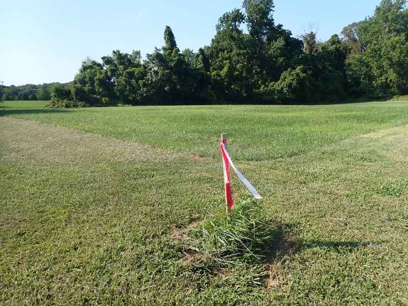
At the top of most modern survey pins, you will find a small plastic or aluminum cap stamped with the surveyor’s license number. That cap is important. It tells you who placed the marker and when.
Where to Look for Survey Pins on Your Property
Markers are placed at the corners of your legal boundary. On a standard rectangular residential lot, that means four corners. On an irregular lot, there may be more, placed at every change of direction along the boundary line.
Here is where to start looking.
Check along your front property line near the sidewalk or curb. Many subdivision lots have a pin set at or near the front corners. Look in the grass, in the ground, or just below the soil surface. A metal detector is one of the most reliable ways to find buried pins, since iron and steel rebar are easy to detect even under several inches of soil.
Check the back corners of the lot next. These are often near the fence line or at the rear of the yard. Vegetation, landscaping, and years of soil movement can push them down or shift them slightly, so scan a small area rather than looking at a single point.
If your property borders a creek, a road, or another natural feature, markers near those boundaries are sometimes set further back or replaced with witness monuments, which are offset markers placed nearby to document a corner that could not be physically set at the true location.
What to Do If You Cannot Find Your Markers
Missing markers are more common than most homeowners expect. Construction activity, landscaping projects, erosion, and decades of mowing can all disturb or bury a pin. Neighbors occasionally move them, whether intentionally or by accident.
If you cannot locate a marker after a thorough search, do not guess and do not place your own stakes. Installing an unauthorized marker is not legally valid and can create serious problems if a future survey finds a discrepancy.
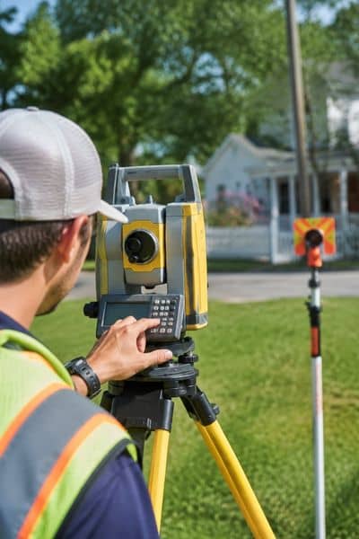
The right step is to hire a licensed Professional Land Surveyor to re-establish the corners. The surveyor will research your deed, review the recorded plat from Davidson County or the relevant county register of deeds, and locate your property corners based on the legal record, not just what is on the ground.
Once located, they will set new pins and provide a certified survey document showing the boundary.
Can You Use Your Property Deed or Plat to Find the Lines Yourself?
Your deed contains a legal description of your property, and the recorded plat shows your lot in relation to the surrounding subdivision. Both are useful starting points for understanding where your boundaries should be, but neither is a substitute for a physical survey.
Deed descriptions can be vague, particularly on older Nashville properties that predate modern GPS-based surveys. Plat maps are drawn to scale but are not always precise enough to locate a corner to within inches in the field. If you are relying on either document to settle a dispute, confirm with a licensed surveyor rather than measuring from the map yourself.
You can request a copy of your recorded plat through the Davidson County Register of Deeds or your county’s equivalent office. Plats are public records and are generally available without charge.
Why This Matters More in Nashville Right Now
Nashville’s growth has put pressure on lot lines throughout Davidson County and surrounding areas. Infill development, teardowns, and new construction in older neighborhoods like East Nashville, Germantown, and Sylvan Park have brought builders and excavators onto lots where original survey pins have not been checked in decades.
When a crew grades a lot or pours a foundation without confirming the boundary, encroachments happen. A structure built even a foot over a property line can trigger legal action, require demolition, or delay a sale. Finding your markers before any ground is disturbed is far less expensive than resolving an encroachment after the fact.
Frequently Asked Questions
Are property line markers legally binding?
A marker placed by a licensed Professional Land Surveyor is legally significant and reflects a certified boundary determination. However, if a marker is found to be in the wrong location due to error or movement, the certified survey document and deed records govern, not the physical pin alone. A surveyor’s certified plat is the legal record.
What if my neighbor removed or moved my survey pin?
Intentionally removing, destroying, or relocating a survey monument is a criminal offense in Tennessee under state law. If you have reason to believe a pin was moved, document the situation and contact a licensed surveyor to re-establish the corner. A real estate attorney can advise on next steps if the situation involves a dispute.
How deep are survey pins typically set?
Most pins are driven 18 to 24 inches into the ground, though depth varies by soil conditions and local practice. In rocky terrain, surveyors sometimes drill and set pins with epoxy. In soft or disturbed soil, pins can sink deeper over time or shift slightly.
Does a property survey show all markers on neighboring lots?
A survey of your parcel will show your corners and may reference adjoining markers if they were found during fieldwork. It will not map the full boundaries of neighboring parcels unless those are included in the scope of work.
Can I hire any contractor to reset a missing survey pin?
No. Only a licensed Professional Land Surveyor can legally set or re-establish a boundary monument in Tennessee. A marker placed by anyone else has no legal standing and could create additional problems if it conflicts with the recorded boundary.