
What Is a Plat of Survey and Why Should Every Property Owner Have One?
If you have ever bought a home or gone through a closing, you may have seen a plat of survey tucked into your paperwork. Most people set it aside without really knowing what it is. That is a mistake. A plat of survey is one of the most useful documents a property owner can have, and knowing what it does can protect you from some very costly surprises.
What Is a Plat of Survey?
A plat of survey is a drawing made by a licensed land surveyor. It shows your property’s exact boundaries, measurements, and key features on a scaled map. Think of it as a visual version of your deed. Your deed describes your property in words. A plat shows it as a picture with precise numbers attached.
It is a legal document. It carries the surveyor’s stamp, signature, and license number. That means it is certified and can be used in legal matters, permit applications, and real estate transactions.
In Tennessee, only a licensed Professional Land Surveyor can produce and certify a plat. Once it is recorded with the county register of deeds, it becomes a permanent part of the public record.
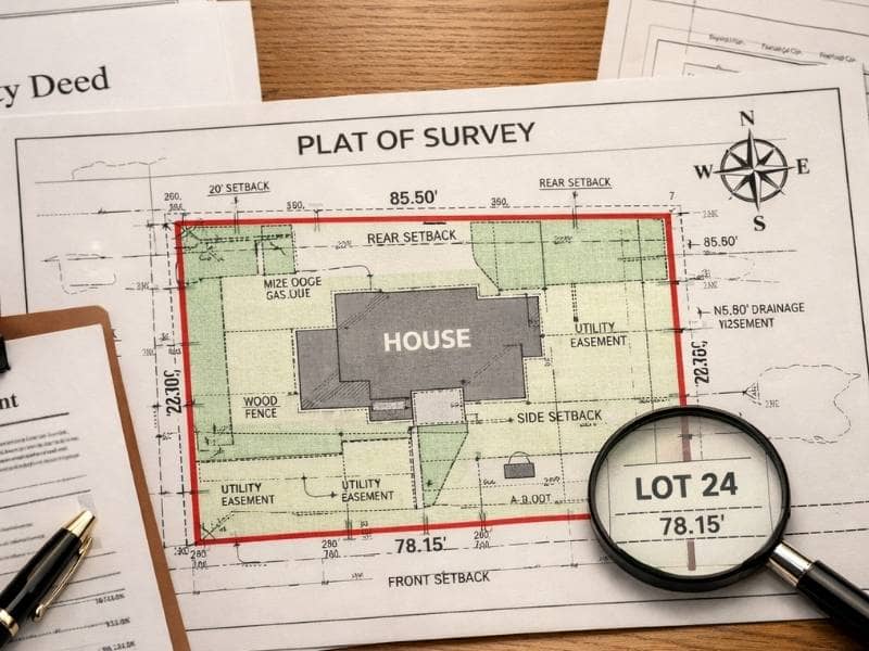
What Does a Plat of Survey Show?
A plat packs a lot of useful information into one document. Here is what you will typically find on one:
- The exact boundary lines of your property with measurements along each side
- The location of your property corners and the type of marker placed there
- The total size of the lot in acres or square feet
- The names of neighboring property owners along your boundary lines
- Any easements on the property, such as utility corridors or drainage paths
- Existing structures on the lot, like a house, garage, or driveway
- A north arrow and scale so you can orient the drawing
- The surveyor’s name, license number, stamp, and the date the survey was done
- A title block showing the owner’s name and property location
If your property is part of a recorded subdivision, the plat will also show lot numbers, street names, and any easements set up when the subdivision was built.
How Is It Different From a Deed?
Your deed is a legal document that proves you own your property. It transfers ownership from one person to another and includes a written description of the land.
A plat of survey takes that written description and turns it into a drawing. Instead of reading through legal language about directions and distances, you can see your lot drawn out on paper with clear measurements.
The two documents work together. The deed says what you own. The plat shows where it is and exactly how big it is. If there is ever a conflict between what the deed says and what is on the ground, a certified plat from a licensed surveyor is the most reliable way to figure out the true boundary.
When Do You Need a Plat of Survey?
There are several common situations where a plat is either required or a very good idea.
Buying or selling property. If the land is not part of a recorded subdivision, most lenders and title companies will ask for a current plat before closing. They need to confirm the boundaries match what the deed says.
Getting a building or development permit. Metro Nashville and Davidson County require a certified plat for many types of permits. That includes new construction, additions, and rezoning requests. Without one, your permit application may not move forward.
Settling a boundary dispute. If a fence, structure, or driveway is in a location that you or your neighbor disagree about, a certified plat is what courts and mediators will look at to figure out where the line actually falls.
Refinancing your home. Some lenders require a current survey plat before approving a refinance, especially if the property has been changed or improved since the last survey was done.
Splitting land into smaller parcels. If you want to divide your land, a subdivision plat must be prepared and recorded with the county before the new lots can be sold separately.
How to Get a Copy of Your Plat
If your home is in a recorded Nashville subdivision, the original subdivision plat is on file with the Davidson County Register of Deeds. You can search for it online or request a copy in person. It is a public record, so there is no charge to view it.
If your property was surveyed on its own, the surveyor who did the work should have given you a copy. If you cannot find it, check with the Davidson County Register of Deeds to see if it was recorded.
If no current plat exists for your property, or if the one you have is very old, a licensed Professional Land Surveyor can perform a new survey and produce a fresh certified plat.
Why an Old Plat Can Cause Problems
A plat from twenty or thirty years ago may not reflect what is on your property today. Structures get added. Easements get granted or removed. Neighboring parcels get replatted. An outdated document can raise red flags with lenders, title companies, and permit offices when you need things to move quickly.
This is especially true in older Nashville neighborhoods. Many properties were surveyed before modern GPS equipment existed. Older plats sometimes have small errors or gaps that only show up when a new survey is done. Finding out about those issues before a sale or a building project is far less stressful than discovering them in the middle of a transaction.